by - Aditya Jalihal
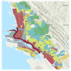
Map created using data from American Panorama, a project at the University of Richmond.
This is the map used to redline neighborhoods: Green and Blue areas were given lower loan rates and meant for white communities, while Yellow and Red coded areas were “less desirable” and reserved for black and brown communities
Your melanin content not only dictates where you can live, but what air you can breathe. In the East Bay, housing and transit policies combined to ensure that communities of color are more likely to have respiratory illnesses.
The practice of redlining (creating racially segregated neighborhoods through housing policies) and the ban of heavy duty fleet vehicles from Interstate 580 in 1963 compounded negative health effects for people of color. This bridging of institutional racism and adverse transit decisions demonstrates how “environmental racism” manifests in the East Bay.
By forcing minority communities into “less desirable” neighborhoods, the Home Owner’s Loan Corporation, was able to ensure that home ownership would only be possible for people of color in areas near environmental hazards, both natural ones such in areas prone to flooding or man-made ones such as manufacturing sites.
The banning of semi-trucks from interstate 580 ensured that the more affluent citizens of Oakland, who live in the hills and not “redlined” areas, had a transit option that was less congested and had fewer diesel emissions.
The coupling of these two policies shows that people of color are facing systemic environmental challenges, entirely by design. When completing analysis of health outcomes near 580 and 880 (which runs through the segregated neighborhoods), it is evident that there is a strong correlation between respiratory illness (such as childhood asthma and lung cancer) and proximity to redlined areas.
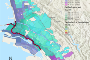
In this map, along a gradient from lighter/greener shades to darker colors, the dark blues represent areas with higher rates of respiratory illness along highway 880 (the red line).